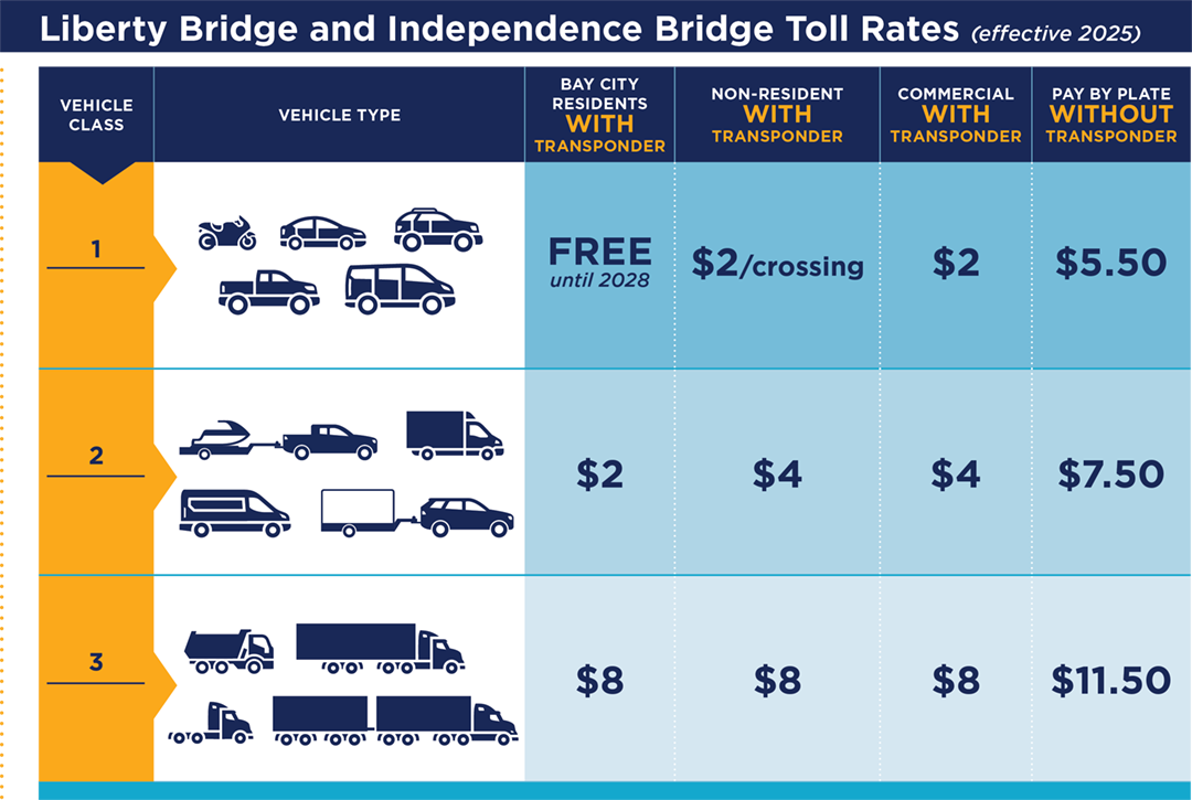
Mackinac Bridge (MBA; per axle, cash/card or MacPass; no E-ZPass), Grosse Ile Toll Bridge (township; one-way fares from an image), and the Bay City Liberty and Independence bridges (Bay City Bridge Partners, since 2025; BC-PASS or E-ZPass, pay by plate; rates from an image). The crossings to Ontario are recorded as not routable.
mi_state.py stops if gi_wayne_county_parkway_bridge no longer says "CURRENT STATUS: | OPEN" (then the round-trip chart and "going to Grosse Ile only" apply). A rehabilitation closure is reported for 2027.bcbp_rate_chart ("effective 2025"); resident discounts end 2028 (Liberty) / 2030 (Independence).fetch_list.py as page.html: rename to image.png.bash chain.sh MI; OSM osm/mi_* (box -90.42,41.69,-82.12,48.31).
Hosts: geo1 (192.168.50.220) holds the sources, builders, drafts, map and API; b100 (192.168.50.14) is the test client. All times are Eastern.
| what | where (geo1 unless said) |
|---|---|
| sources list | /home/geo1/maps/toll/MI/urls.txt (name <tab> URL) |
| archived sources | /home/geo1/maps/toll/MI/sources/<name>/<YYYY-MM-DD>/ (file + meta.json: url, fetched, sha256) |
| builder | /home/geo1/system/handbuilt/mi_state.py; shared code toll_common.py |
| OpenStreetMap inputs | /home/geo1/system/handbuilt/osm/mi_* (cut from /home/geo1/maps/osm/us-latest.osm.pbf) |
| output | draft /srv/toll/draft/MI/ (the builders write here); published /srv/toll/MI/ (copied from the draft by promote.py publish). The map and the API read the published page, or the draft while it is listed for review |
| toll engine | source /home/geo1/maps/web/tolls.js, served copy /srv/maps/tolls.js (the API runs the served copy) |
| API | /home/geo1/maps/api/server.mjs on 127.0.0.1:8090 behind nginx /api/; pid in logs/test.pid |
| regression trips | b100: ~/apitest/site/cases.json, runner ~/apitest/run.py, browser check ~/apitest/browser.mjs |
python3 /home/geo1/system/handbuilt/fetch_list.py MI [name ...] (no names = every line of urls.txt). A new source: add a line to urls.txt first, then fetch it by name.node ~/apitest/fetch_b100.mjs <out> <name>=<url> ..., then rsync -a <out>/ geo1@192.168.50.220:/home/geo1/maps/toll/MI/sources/. Its meta.json records that it came from b100.diff, pdftotext -layout for PDFs). Same content: nothing to do. Changed amounts or a new effective date: rebuild (step 2) and update the expected amounts of the affected regression trips from the operator's own figures.python3 /home/geo1/maps/toll/bin/tollup.py MI update fetches the adapter's sources (bin/adapters/mi.py), stores a document only when its content changes, writes one rate file per version under /home/geo1/maps/toll/MI/rates/ and appends every price change to history.csv (every run to runs.log). TOLL_WEB=/home/geo1/maps/toll/corpus python3 /home/geo1/maps/toll/bin/publish.py MI writes the corpus /home/geo1/maps/toll/corpus/MI from it (DE: plain publish.py DE writes /srv/toll/DE). Never hand-edit either. Then rebuild the draft (step 2) so it picks up the new rates.
cd /home/geo1/system/handbuilt && python3 mi_state.pybash /home/geo1/system/handbuilt/chain.sh MI (logs in /tmp/mi1.log ... mi6.log; it prints the points, any point on no road and the untied count). The builders written since October 2026 share state_kit.py (sources, booths, terms, rows, write) and own_state.py (keeps a state's untied list to toll nodes inside the state, by the local geocoder; cache osm/node_state.json).cd /home/geo1/system/handbuilt; H=$(ls osm/mi_highways_*.geojsonseq); J=$(ls osm/mi_junctions_*.geojsonseq)
python3 mi_state.py && python3 osm_streets.py MI $H $J && python3 mi_state.py && python3 osm_snap.py MI && python3 toll_ways.py MI && python3 mi_state.pytoll_ways.py's output: nodes claimed by two points: {} and points on no road: [] must both be empty.OSM way <id>) needs that way in osm/mi_lane_ways.json (the builder writes it). A point on a road priced entry to exit needs gantry in its location name, or toll_ways.py treats it as a position-only exit marker.osm/ny_not_toll_nodes.json (congestion-zone gantries that are not tolls); every state's untied list leaves those out, so rebuild NJ and PA after NY.tolls.js when it starts. Restart it: cd /home/geo1/maps/api && kill $(cat logs/test.pid); (nohup /home/geo1/maps/node/bin/node server.mjs > logs/server.log 2>&1 & echo $! > logs/test.pid) (it is started by hand, not a service).python3 ~/apitest/run.py ~/apitest/site/cases.json. Every trip must be OK. Add a trip for every rate or rule you change, with the amount taken from the operator's own source.tolls.js): edit /home/geo1/maps/web/tolls.js, check with /home/geo1/maps/node/bin/node --check, copy to /srv/maps/tolls.js with sudo install -o www-data -g www-data -m 644, restart the API, run the trips.The builders match toll points to the OSM way ids the router drives, so the extracts here must come from the same us-latest.osm.pbf the router (Valhalla, /home/geo1/maps/valhalla_data) was built from (now 2026-09-27). New OSM data means: rebuild the router tiles, then for each state cut the box, rebuild its OSM inputs and run the full chain, then compare untied_toll_nodes.csv and the estimated positions below. The box for MI and the cutting commands are in the state's procedure above; the toll-node and way index comes from python3 tollnode_ways.py MI.
A rebuild writes the draft (/srv/toll/draft/MI); the published page (/srv/toll/MI) does not change. python3 /home/geo1/maps/toll/bin/promote.py review MI lists the draft for review: the map and the API then read it instead of the published page. Run the regression trips from b100. After approval, python3 /home/geo1/maps/toll/bin/promote.py publish MI copies the draft to /srv/toll/MI (the previous page is kept under /home/geo1/maps/toll/MI/published/<time>/) and takes it off the review list. After a change, update the coverage line for MI in the API page (/api.html, generator /home/geo1/maps/api/doc/api_page.py) and rebuild this page: python3 /home/geo1/system/handbuilt/maintain_pages.py MI.
Each fetch is kept in its own dated folder under /home/geo1/maps/toll/MI/sources/<name>/; the builder always reads the newest one, so a new fetch takes effect at the next rebuild and the old one stays for comparison.
| id | facility | operator | points | rate / trip rows | effective dates in the rows | source |
|---|---|---|---|---|---|---|
MI-MBA | Mackinac Bridge | Mackinac Bridge Authority (MBA) | 1 | 7 | 2026-10-09_observed | mba_fare_schedule |
MI-GITB | Grosse Ile Toll Bridge | Grosse Ile Township (owner since 2025-03-31) | 1 | 19 | 2025-04-01 | gi_fares_one_way |
MI-BCBP-LIB | Liberty Bridge (Bay City) | Bay City Bridge Partners (United Bridge Partners concession) | 1 | 12 | 2025-01-01 | bcbp_rates |
MI-BCBP-IND | Independence Bridge (Bay City) | Bay City Bridge Partners (United Bridge Partners concession) | 1 | 12 | 2025-01-01 | bcbp_rates |
None: every position comes from an official layer or a mapped toll node.
R2a: 4, amounts: 1, built: 1, direction: 4, engine: 1, not: 6, watch: 1 (all in decisions.csv).
None.
Toll booths / gantries mapped in OpenStreetMap on or near this state's roads that no toll point claims; a route through one lists it under unpriced. After an OSM refresh, look at new ones here (untied_toll_nodes.csv): a new gantry on a priced road means a point is missing.
Run from b100 (never on geo1): python3 ~/apitest/run.py ~/apitest/site/cases.json. Every trip must come back OK; a changed amount is either a rate change (update the expected amount from the operator's own source) or a fault.
| trip | expected |
|---|---|
| MI Mackinac Bridge northbound, cash car ($4.00) | $4.00 |
| MI Mackinac Bridge southbound, E-ZPass DE (not accepted: cash) car ($4.00) | $4.00 |
| MI Mackinac Bridge northbound, cash 5-axle truck ($25.00) | $25.00 |
| MI Grosse Ile Toll Bridge, cash car ($3.50) | $3.50 |
| MI Liberty Bridge (Bay City), E-ZPass DE car ($2.00) | $2.00 |
| MI Independence Bridge (Bay City), pay by plate car ($5.50) | $5.50 |